Marine protected areas in Québec
The main objective of the network of marine protected areas (MPAs) is to ensure the long-term maintenance of marine biodiversity and key ecological components in Québec.
Québec’s overall marine territory encompasses the St. Lawrence River and the coastal waters of Northern Québec. Plankton and numerous fish and marine mammal species are found in the St. Lawrence River. The Estuary and Gulf of St. Lawrence are highly contrasted environments with the hottest surface water in Atlantic Canada in the summer and the biggest quantities of sea ice during the winter. The northern portion of the maritime territory spans more than 3 000 km. The repercussions of climate change in these environments occur more rapidly and affect the entire marine ecosystem. Climate change also affects inshore birds and seabirds, especially the deterioration or loss of their specific habitats and the time lag between staging areas and the availability of food.
For this reason, the territories identified to be protected as marine areas were selected by taking into consideration oceanographic and ecological characteristics, as well as the geology of the targeted environments. Each zone is delimited and has its own conservation objectives. The conservation measures and geographic boundaries of the marine protected areas are elaborated in consultation with stakeholders. They can be regulated and managed according to the following Québec designations:
- marine protected areas designated by ad hoc legislation, such as the St. Lawrence Marine Park;
- marine reserve;
- proposed aquatic reserve.
As a result of the Act to Amend the Natural Heritage Conservation Act and Other Provisions (2021, c.-1), marine reserve status, which is better adapted to marine environments, has replaced aquatic reserve status.
Until the legal status of a marine protected area is established, the designation of a territorial reserve for protected area purposes (TRPAP) marks the first step in protecting marine environments. The TRPAP is a transitional administrative tool, whose protective measures must be enhanced when a marine protected area is created.
As described by the International Union for Conservation of Nature (IUCN), marine protected areas are divided into management categories based on their conservation objective, as illustrated in the table below.
| Catégories UICN | Taille | Objectif |
| Ia | Often small |
Conserve exceptional ecosystems |
| Ib | Usually large | Protect wilderness areas |
| II | Usually large | Protect the integrity of the marine ecosystem |
| III | Usually small | Protect sites containing natural monuments |
| IV | Often small | Maintain, conserve and restore species and habitats |
| V | Usually large | Protect and maintain seascapes as well as the interaction of people and nature for resource sustainability |
| VI | Usually large | Protect natural ecosystems and use resources sustainably |
In order to better understand the possible
applications of marine protected area categories V and
VI, the Ministère mandated Université Laval to collect
this knowledge. The report entitled “Étude de cas d’aires marines
protégées de catégorie V (paysage protégé) et de catégorie VI
(APUDR)
(French, ![]() PDF, 22 MB)
PDF, 22 MB)![]() ” presents a study of seven
cases of protected landscapes and seven cases of
protected areas with sustainable use of resources in 11
countries, a synthetic comparative analysis of the cases
studied, and recommendations for the implementation of
Categories V and VI marine protected areas in Québec.
” presents a study of seven
cases of protected landscapes and seven cases of
protected areas with sustainable use of resources in 11
countries, a synthetic comparative analysis of the cases
studied, and recommendations for the implementation of
Categories V and VI marine protected areas in Québec.
The objectives of marine conservation
In response to Aichi Biodiversity Target 11 of the Convention on Biological Diversity, the Québec government through its maritime strategy has committed itself to attaining the international target pertaining to the marine environment. The establishment of a representative network of marine protected areas covering at least 10% of the estuary and the Gulf of St. Lawrence has been achieved in collaboration with the government of Canada.
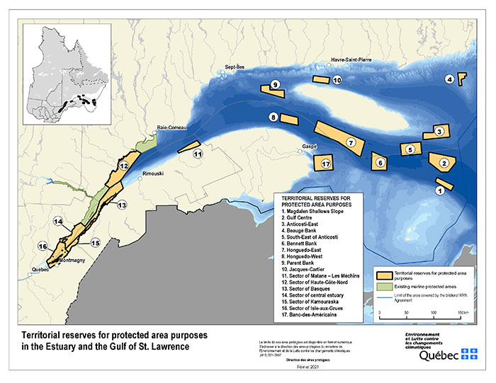
On December 13, 2020, the Québec government announced the official creation of 17 territorial reserves for protected area purposes (TRPAPs) totalling more than 14 000 km2, i.e., six territories in the estuary and 11 in the Gulf of St. Lawrence. The Minister of the Environment and the Fight Against Climate Change unveiled the additions to the Québec network of marine protected areas, which now covers 10.4% of the territory.
Canada-Québec collaboration agreement
Almost without exception, all the proposed protected
marine areas in Québec are jointly selected, planned,
and implemented with the government of Canada under a
collaboration agreement
(French ![]() PDF,
2,2 MB)
PDF,
2,2 MB)![]() in force since March 19, 2018.
in force since March 19, 2018.
The projects are the results of analyses of the biological components of the studied sectors, such as the presence of threatened species, of fragile ecosystems, or of breeding areas, depending on conservation priorities. Moreover, a
representativeness analysis was conducted in all sectors of ecological interest in the Estuary and the Gulf of St. Lawrence
(![]() PDF,
2,7 MB)
PDF,
2,7 MB)![]() that are under discussion between the governments of Québec and Canada.
that are under discussion between the governments of Québec and Canada.
Existing marine protected areas
Existing marine protected areas are included in the Register of Protected Areas and OECMs in Québec :
- the Saguenay-St. Lawrence Marine Park;
- the Bonaventure River Estuary marine reserve;
- the proposed Manicouagan aquatic reserve;
- Banc-des-Américains marine protected area.
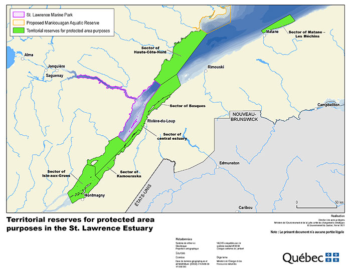
The Saguenay-St. Lawrence Marine Park
The Saguenay-St. Lawrence Marine Park protects 1 245 km2 of marine territory. It encompasses outstanding ecosystems, more than 1 800 animal and plant species and marine mammals, including the blue whale and the St. Lawrence beluga, which are threatened species. By regulating the activities allowed in the park, the biodiversity is protected there from the seabed to the surface of the water.
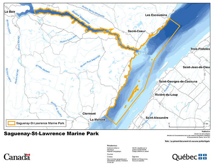
In September 2023, the Government of Canada and the Gouvernement du Québec signed the Accord Canada-Québec relatif au projet d’agrandisement du parc marin du Saguenay—Saint-Laurent, which defines the provisions for cooperation on implementing the parc marin Saguenay–Saint-Laurent expansion project. This expansion would give permanent legal protected status to a significant portion of the estuary’s territorial reserves for protected area purposes (see next section).
To obtain additional information, please visit the marine park’s website![]() .
.
The Bonaventure River Estuary marine reserve
On March 19, 2021, the Bonaventure River Estuary Aquatic Reserve became the Bonaventure River Estuary Marine Reserve, pursuant to section 63 of the Act to amend the Natural Heritage Conservation Act and other provisions. Sections 46, 47 and 49 of the Natural Heritage Conservation Act (chapter C‑61.01), as well as the Bonaventure River Estuary Conservation Plan, as they read on March 18, 2021, continue to apply to the territory of the Bonaventure River Estuary Marine Reserve until the entry into force of the regulation that will apply to that reserve. This marine reserve
(conservation plan
![]() PDF, 450 KB)
PDF, 450 KB)![]() )
is situated in the Gaspésie—Îles-de-la-Madeleine regions. It covers an area of 1.8 km2 and spans the estuary formed at the mouth of the Bonaventure River.
)
is situated in the Gaspésie—Îles-de-la-Madeleine regions. It covers an area of 1.8 km2 and spans the estuary formed at the mouth of the Bonaventure River.

The Bonaventure River estuary includes one of Québec’s 10 estuarial barachois. A barachois is a coastal lagoon partially or fully separated from the ocean by a sandbank or pebbles. Extensive filamentous algae beds, especially hollow green weed, a species highly tolerant of variations in water salinity, are observed in the sector. What is more, species such as Atlantic salmon and rainbow smelt reproduce in the Bonaventure River and migrate through the estuary to the sea, where they grow to maturity. Lastly, some water birds make abundant use of the channel that separates the Îles Arsenault during migration. Canada geese, black ducks, mallards, and green-winged teals are the most abundant species.
The proposed Manicouagan aquatic reserve
The proposed Manicouagan aquatic reserve (conservation plan
- ![]() PDF, 186 KB
PDF, 186 KB![]() ) is situated on the north shore of the St. Lawrence Estuary. It encompasses the shoreline along the municipalities of Ragueneau, Chute-aux-Outardes, Pointe-aux-Outardes and Pointe-Lebel. It also adjoins the territories of the Pessamit Reserve and the municipality of Colombier. It covers an area of roughly 712 km².
) is situated on the north shore of the St. Lawrence Estuary. It encompasses the shoreline along the municipalities of Ragueneau, Chute-aux-Outardes, Pointe-aux-Outardes and Pointe-Lebel. It also adjoins the territories of the Pessamit Reserve and the municipality of Colombier. It covers an area of roughly 712 km².
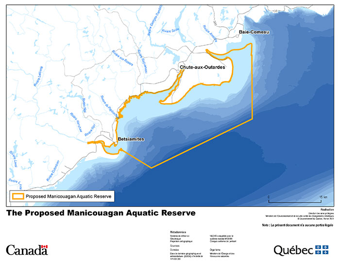
The proposed aquatic reserve encompasses an array of rich and diverse habitats:
- the estuaries of the Manicouagan River, the Geese River, and the Betsiamites River;
- maritime salt marshes, which are the planet’s most productive habitats;
- sandy tidal flats that shelter capelin spawning grounds;
- eelgrass beds;
- islands;
- seabeds that display abundant biodiversity.
A wide variety of fish and invertebrates are found in the territory, including snow crab, northern shrimp, and Greenland halibut. Capelin, rainbow smelt, and Atlantic herring are some of the species that spawn there. They constitute a significant share of the food resources of birds, fish, and marine mammals, such as whales and seals, which frequent the area.
To learn more about this marine protected area:
- watch this video (French)
 ;
; - read the report entitled “Portrait des populations de phoques communs et de phoques gris dans le Saint-Laurent dans le cadre du suivi de l’échouerie dans la réserve aquatique projetée de Manicouagan”
(French,
 PDF, 962 KB
 ).
).
Banc-des-Américains marine protected area
The Banc-des-Américains marine protected area is the first proposed joint project covered by the Canada-Québec collaborative agreement to establish a network of marine protected areas in Québec. Since March 2019, an intergovernmental agreement
(![]() PDF, 4,6 MB
PDF, 4,6 MB![]() ) has been in force pertaining to the designation of the Banc-des-Américains joint marine protected area.
) has been in force pertaining to the designation of the Banc-des-Américains joint marine protected area.
As a result, this marine protected area benefits from dual protection status. The proposed aquatic reserve status (conservation plan
![]() PDF, 3,2 MB)
PDF, 3,2 MB)![]() ) granted according to the NHCA is added to the marine protected area status established by Fisheries and Oceans Canada according to the Oceans Act.
) granted according to the NHCA is added to the marine protected area status established by Fisheries and Oceans Canada according to the Oceans Act.
The Banc-des-Américains marine protected area is situated east of the Gaspé Peninsula in the territory of the Gaspé Municipality to the north and the Percé Municipality to the south. It represents an area of roughly 1 000 km2 and encompasses the shoal of the American Bank.
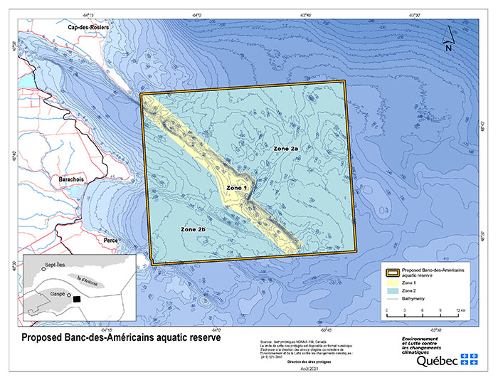
The environment is unique in the natural province of the Estuary and Gulf of St. Lawrence. This area shows a high biological productivity due to a combination of oceanographic phenomena and a broad range of habitats which favor high nutrient salts inputs and thus the development of phytoplankton.
The Banc-des-Américains marine protected area is characterized by the diversity of benthic fauna living on the seabed, including snow crab, rock crab, Northern lobster, waved whelk, Icelandic scallop, and Northern shrimp. Significant algal biomass, which underpins the food chain in this sector, attracts a wide array of fish species. Species such as Atlantic cod, Greenland halibut, beaked redfish, Atlantic herring, and Atlantic mackerel are abundant.
The sector that the Banc-des-Américains marine protected area targets is also a feeding area or transit zone for several marine mammal species. Lastly, the sector provides abundant food for seabird species such as northern gannets, Atlantic puffins, and razorbills.
Proposed protected marine areas
Several sectors are under study in the estuary and Gulf of St. Lawrence. In the summer of 2019, the
governments presented the two projects covering the estuary
and the Gulf of St. Lawrence to the Indigenous groups and
relevant stakeholders (Information
meeting
2019
- ![]() PDF,
3,8 MB
PDF,
3,8 MB![]() ).
).
Joint works conducted with the Government of Canada are continuing, as well as procedures related to the joint marine protected area projects announced in June 2019. The next step will be the consultation step, which will allow the elaboration of potential conservation measures and discussions with the Indigenous groups and relevant stakeholders. This step will be followed by a formal consultation of the Indigenous groups and relevant stakeholders, as well as the public, on each of the projects (boundaries of the projects, conservation objectives, and conservation measures).
To comply with its international commitments and attain by late 2020 its target of 10% marine protected areas, the Québec government decided to adopt an administrative action by designating the territorial reserves for protected area purposes (TRPAPs), which marks the first step in the protection of the marine environment. The purpose is to attribute legally protected status pursuant to the Natural Heritage Conservation Act or the Act respecting the conservation and development of wildlife.
Territorial reserves for protected area purposes (TRPAPs)
The Minister of the Environment and the Fight Against Climate Change, the Minister of Energy and Natural Resources, and the Minister of Forests, Wildlife and Parks jointly ensure the protection of territorial reserves for protected area purposes (TRPAPs) in marine environments.
The designation of TRPAPs entails the prohibition of any form of activity associated with natural resource exploration and exploitation (mining, gas, and oil), hydrocarbons transportation by gas pipeline and oil pipeline, the exploitation of hydropower, and any commercial or industrial energy production in the territories overall. The presence of TRPAPs is also considered when applications for authorizations and the granting or issuance of rights under the laws of Québec are analyzed. The Minister of Energy and Natural Resources ensures the maintenance of the requisite administrative and legal provisions to prohibit them and adopts the necessary administrative and legal provisions until a decision is reached concerning the attribution of legally protected status for such territories. Moreover, the ministers contribute to ensuring compliance with the key objective of such territories, i.e. the conservation of the marine environment.
On December 13, 2020, the Québec government announced the designation of 17 TRPAPs in the estuary and the Gulf of St. Lawrence, which correspond to areas that are the subject of joint work under the Canada-Québec collaborative agreement to establish a network of marine protected areas in Québec. The Réserve de territoire aux fins d’aire protégée du Banc-des-Américains was replaced on October 7, 2021 by the Réserve aquatique projetée du Banc-des-Américains.
-
Memory (French)
TRPAP in the St. Lawrence Estuary
Six sectors have been designated TRPAPs in the St. Lawrence estuary and they represent an area of 5 033 km2. The sectors were chosen to protect:
- vulnerable marine mammal species and their habitats;
- vulnerable fish species and their habitats;
- forage species, which are the prey of marine mammals, as well as their habitats;
Description of TRPAPs
- Sector of Isle-aux-Grues (zoomed map –
protective measures PDF,
281 KB): This is a significant biological productivity area where vulnerable fish species such as striped bass, lake
sturgeon, Atlantic sturgeon, and rainbow smelt are found. It occupies a geographic area of 914 km2.
- Sector of central estuary (zoomed map –
protective measures PDF,
280 KB):This 1 743 km2 sector is an essential habitat for belugas outside the St. Lawrence Marine Park. It is also
important for the reproduction and growth of several species that belugas eat, such as capelin and Atlantic herring.
- Sector of Kamouraska (zoomed map –
protective measures PDF,
280 KB):This 357 km2 sector is important for the reproduction and growth of beluga food sources such as capelin, Atlantic
herring and rainbow smelt. It also includes an essential striped bass habitat.
- Sector of Basques (zoomed map –
protective measures PDF,
274 KB): This 133 km2 sector encompasses significant areas for the reproduction and growth of capelin and Atlantic herring.
- Sector of Haute-Côte-Nord (zoomed map –
protective measures PDF,
285 KB):This 1 569 km2 sector is a feeding area for rorquals since a concentration of krill and species that fin
whales eat, such as capelin, Atlantic herring, and American sand launce, are found there.
- Sector of Matane – Les Méchins (zoomed map –
protective measures PDF,
81 KB):This 316 km2 sector is being studied since it is blue whale feeding area.
Protective measures in force
The protective measures in force in the TRPAPs, which can be viewed by clicking on the link of each sector, will be completed when they will obtain legally protected status.
Links of Interest
- Ecological and socio-economic overviews of these territories:
- Report from the Sud-de-l’Estuaire ZIP Committee
(French, PDF, 12.4 MB )
- Report from the Rive Nord de l’Estuaire ZIP Committee (Haute-Côte-Nord sector TRPAP)
(French, PDF, 12.3 MB )
- Report from the Saguenay-Charlevoix ZIP Committee
(French, PDF, 8.9 MB )
- Report from the Sud-de-l’Estuaire ZIP Committee
(French,
To obtain additional information on the joint marine protected area project:
https://www.dfo-mpo.gc.ca/oceans/canada-quebec-agreement-entente/index-eng.html
![]()
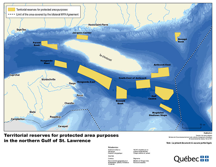
TRPAP in the northern Gulf of St. Lawrence
Ten sectors have been designated TRPAPs, covering an area of 8 148 km2. The sectors have been selected to:
- intensify the protection of cold-water corals and sponges, which are known to be fragile species that recover slowly when disturbed, since, as they grow, many of these species create complex structures that numerous other marine species use for shelter, food, and growth;
- protect ecosystems that shelter cold-water corals and sponges;
- promote high biodiversity in the sectors.
These ten TRPAPs are superimposed to marine refuges of the government of Canada, in which fishing management measures are already in place to ban on bottom-contact fishing gear, i.e. bottom trawl, dredge, bottom seine, traps, bottom longline and gillnet.
Description of TRPAPs
- Parent Bank (zoomed map –
protective measures PDF,
277 KB):This 530 km2
zone encompasses a high concentration of sponges.
- Honguedo-West (zoomed map –
protective measures PDF,
277 KB):This 496 km2 sector is under study because of its high concentration of three species of sea pens, Pennatula aculeata, Pennatula grandis and Anthoptilum grandiflorum.
- Honguedo-East (zoomed map –
protective measures PDF,
274 KB):This 2 338 km2 zone provides a habitat for high concentrations of sponges and four species of sea pens, Halipteris finmarchica, Anthoptilum grandiflorum, Pennatula grandis and Pennatula aculeata.
- Jacques-Cartier (zoomed map –
protective measures PDF,
274 KB):The highest concentration of sponges is found in this sector compared with all the coral and sponge conservation zones established in the Estuary and Gulf of St. Lawrence. The area targeted covers 346 km2.
- Bennett Bank (zoomed map –
protective measures PDF,
274 KB):A high concentration of the sea pen species Anthoptilum grandiflorum is found in this 821 km2 zone.
- South-East of Anticosti (zoomed map –
protective measures PDF,
276 KB): This 845 km2 sector has a high concentration of sponges.
- Anticosti-East (zoomed map –
protective measures PDF,
276 KB):This 939 km2 sector is recognized for its high concentration of sponges.
- Beaugé Bank (zoomed map –
protective measures PDF,
274 KB): This 215 km2 area has a high concentration of sponges.
- Gulf Centre (zoomed map –
protective measures PDF,
275 KB):The highest known concentration of the sea pen species Anthoptilum grandiflorum in the Estuary and Gulf of St. Lawrence is found in this 1 284 km2 zone.
- Magdalen Shallows Slope (zoomed map –
protective measures PDF,
274 KB):A very high concentration of the Pennatula grandis and Anthoptilum grandiflorum sea pen species are found in this 335 km2 sector.
Protective measures in force
The protective measures in force in the TRPAPs, which can be viewed by clicking on the link of each sector, will be completed when they will obtain legally protected status.
To obtain additional information on the joint marine protected area project:
https://www.dfo-mpo.gc.ca/oceans/canada-quebec-agreement-entente/index-eng.html
![]()
Parc marin Anticosti–Mingan creation project
In November 2023, a joint announcement by the governments of Québec and Canada confirmed the decision to undertake work toward the creation of a new joint marine park in the area of Île d’Anticosti and the Mingan archipelago. The Parc marin Anticosti–Mingan would combine the protection of natural ecosystems and cultural values with the sustainable use of renewable natural resources. It would help conserve this marine region and highlight its cultural and ecological significance for future generations.
In March 2025, the governments of Québec and Canada released the surface area of the preliminary study area for this project.
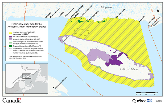
At the scale of the Golfe du Saint-Laurent, the preliminary study area stands out for its oceanographic, ecological, and cultural richness. It is notably home to extensive kelp forests and high concentrations of phytoplankton, making it an ideal habitat for many marine mammals. The area also includes major seabird colonies, sponge zones, and species at risk, such as the American eel, Atlantic wolffish, and cod. The creation of a marine protected area in this region would establish a land-to-sea continuum of protection with existing protected areas, including the Parc national d’Anticosti, the Réserve de biodiversité d’Anticosti, the Gouvernement du Québec’s ecological reserves that protect the Anticosti site inscribed on UNESCO World Heritage List, and the Mingan Archipelago National Park Reserve (Parks Canada).
The boundaries of the preliminary study area follow the high-water mark, but exclude all islets and islands. They also exclude all existing maritime infrastructure, such as wharves, marinas, and ports. Existing port facilities, for instance in Havre-Saint-Pierre, Port-Menier, and Baie-Johan-Beetz, would therefore not be included in the marine park. Lastly, this project would allow the Réserve de territoire aux fins d’aire protégée de Jacques-Cartier, which overlaps with the marine refuge established by Fisheries and Oceans Canada, to be granted permanent legal protection status.
In the next steps, the governments of Québec and Canada will take the time required to meet with relevant stakeholders, including First Nations and coastal communities, regional and municipal organizations, fishers, aquaculture producers, research groups, and local businesses, in order to gather their views and comments. The governments wish, among other things, to discuss the conservation gains and the potential social, ecotourism, and economic benefits resulting from the creation of the Parc marin Anticosti–Mingan. The management arrangements best suited to the area’s unique context will also be addressed. These efforts will also serve to refine the conservation and enhancement priorities and determine the boundaries of the area to be proposed for the project during public consultations. The project will thus be tailored to the specific realities of the region.
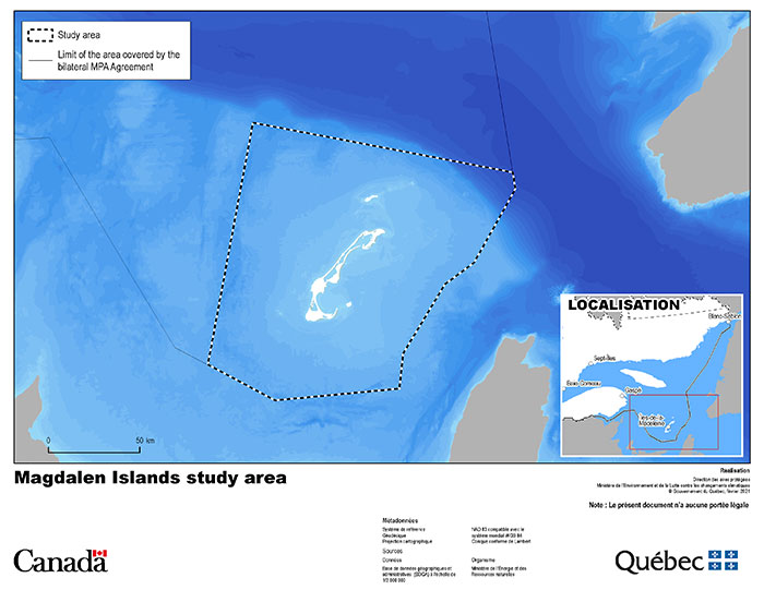
Magdalen Islands project - abandoned
A pre-feasibility study conducted between 2012 and 2014 concerning the establishment of a marine protected area in the Magdalen Islands confirmed the diversity of the marine territory and its potential. The study area covered roughly 17 000 km² in the heart of the Golfe du Saint-Laurent and constituted a representative cross-section of this vast region. On June 27, 2019, the Ministère and Parks Canada launched a feasibility study to revive the project, which aimed to protect the marine environment and promote it in the same way as the maritime cultural heritage that defines the Magdalen Islands. The project was carried out in close collaboration with the coordination committee made up of representatives from the Magdalen Islands and gave a central role to the fishing and mariculture sector.
After several years of collaborative work to conceptualize the Magdalen Islands marine fishing park project, the coordination committee agreed, on February 13, 2025, to end the initiative. Parks Canada and the Ministère then decided to respect the committee’s will and directions.
Useful links
- Étude de préfaisabilité 2012-2014:
- Volume 1 - Rapports des volets écologiques et socioéconomiques - (French, PDF, 6,6 MB)
- Rapport d’étude et analyse écologique - Updated in 2023 - (French, PDF, 4,2 MB)
- Rapport d’étude et analyse écologique - Updated in 2023 - (French,
- Volume 2 - Caractérisation de la communauté et identification des attentes et préoccupations relativement à une aire marine protégée aux Îles-de-la-Madeleine - (French, PDF, 2,5 MB)
- Volume 3 - Atlas Cartographique - (French, PDF, 9,9 MB)
- Atlas cartographique des Îles-de-la-Madeleine - Updated in 2022 - (French PDF, 26,7 MB)
- Atlas cartographique des Îles-de-la-Madeleine - Updated in 2022 - (French
- Volume 1 - Rapports des volets écologiques et socioéconomiques - (French,
- Contribution économique du secteur des pêches et de la mariculture des Îles-de-la-Madeleine - (French, PDF, 2,8 MB)
To find out more about the St. Lawrence River
Contact
If you have questions or comments on the proposed protected marine areas, please contact us at aires.marines@environnement.gouv.qc.ca.